
Hunting Gps Maps, Topo +Trails
In-app purchases
100K+
Downloads

PEGI 3
info


About this app
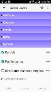
This hunting GPS app provides access to property line maps, parcels & public
lands, land ownership details. Map layers for 50+ states include hunting
zones, restricted areas, possible access areas, state refgues and more.
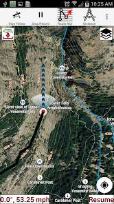
Vector topo maps with most accurate USGS elevation contours, hiking & biking
trails. Coverage includes all US states.
► Vector Topo Maps
√ Beautiful & detailed Hardware/GPU accelerated vector maps (text stays upright on rotation)
√ Vector USGS contours (Change height to ft or meter).
√ Covers popular hiking & biking trails and paths
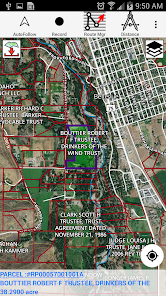
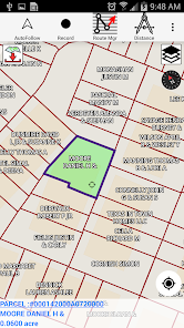
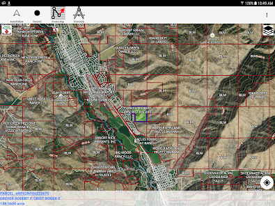
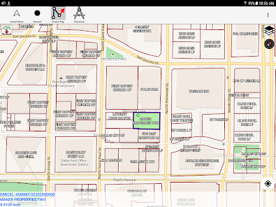
► Parcel Maps
√ Includes following ownerhsip attributes (where available)
* Owner name and Owner address
* Site Address
* Parcel ID Total Value
► Hunt Planning maps
√ Possible Public Access
√ Public lands and Parcels
√ Hunting Zones
√ Game Distribution
√ Restricted Ares
√ Portions
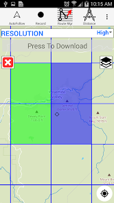
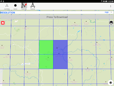
► Offline vector maps
√ Easy to download offline topos
► PLSS maps
√ PLSS Townships and Sections (US Wide coverage)
► Custom base maps
√ Switch base maps between vector topos, hybrid satellite imagery and more
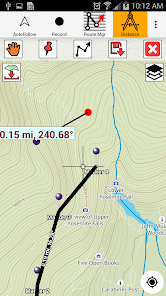
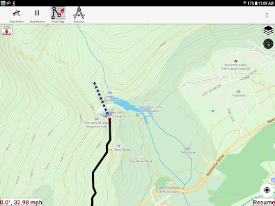
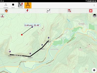
►GPS FEATURES
√ Record Tracks
√ Enter or import Waypoints.
√ Auto Follow
* Real Time Track Overlay
* Predicted Path Vector
* Course Up(Text stays upright)
* Speed & Heading
√ Route Assistance With Voice Prompts
* Prompts when approaching a boating route marker
* Continous distance & ETA updates
* Alerts when off route
* Alerts when moving in wrong direction
►ROUTE MANAGEMENT / TRIP PLANNING
√ Create New Route/Edit Existing Routes
√ Move Points
√ Add points to an existing route leg
√ Delete / Rename points
√ Import GPX,KML & KMZ files
√ Plot/Edit Routes
√ Enter Waypoints
√ Share/Export Routes,Tracks&Markers
√ Reverse Routes
► SHARING
* Share tracks/routes/markers on Facebook & Twitter
* Export tracks/routes/markers as compressed GPX files.
► Topo & Trail Maps for National Parks
Detailed topographic trail maps are included for national and state park including::
√ Great Smoky Mountains
√ Grand Canyon
√ Zion
√ Rocky Mountain
√ Yosemite
√ Yellowstone
√ Acadia
√ Olympic
√ Denali
√ Glacier
► Weather Forecasts
Animate weather forecast overlays for the following.
√ Wind Speed and Directions (GFS & ECMWF)
√ Wave Heights (Swell + Wind combined) and Direction(GFS & ECMWF)
√ Pressure (MSL) (GFS & ECMWF)
√ Precipitation
√ Air Temperature (GFS & ECMWF)
√ Gust
√ Lake Temperatures
Comfortable Weather Settings
√ Automatically Highlight Harsh Weather Forecasts
√ Weather settings are customizable based on your preferences.
► Suggested Uses for i-Hunting Topo Maps
√ Hunt Planning & Recon
√ Off trail and On trail hiking
√ Backpacking : Use Topos of National Forests and Wilderness areas with GPS
√ Snow Sports (Snow Shoeing, Skiing, Snowboarding, Snow Mobiling)
√ SAR (Search and Rescue)
The i-Hunting application can turn your phone into full fledged outdoors GPS unit (like Garmin ® or Magellan ® outddor GPS). The app compliments the gear you got from Dick's ® , REI ® , Cabelas ® etc.
lands, land ownership details. Map layers for 50+ states include hunting
zones, restricted areas, possible access areas, state refgues and more.
Vector topo maps with most accurate USGS elevation contours, hiking & biking
trails. Coverage includes all US states.
► Vector Topo Maps
√ Beautiful & detailed Hardware/GPU accelerated vector maps (text stays upright on rotation)
√ Vector USGS contours (Change height to ft or meter).
√ Covers popular hiking & biking trails and paths
► Parcel Maps
√ Includes following ownerhsip attributes (where available)
* Owner name and Owner address
* Site Address
* Parcel ID Total Value
► Hunt Planning maps
√ Possible Public Access
√ Public lands and Parcels
√ Hunting Zones
√ Game Distribution
√ Restricted Ares
√ Portions
► Offline vector maps
√ Easy to download offline topos
► PLSS maps
√ PLSS Townships and Sections (US Wide coverage)
► Custom base maps
√ Switch base maps between vector topos, hybrid satellite imagery and more
►GPS FEATURES
√ Record Tracks
√ Enter or import Waypoints.
√ Auto Follow
* Real Time Track Overlay
* Predicted Path Vector
* Course Up(Text stays upright)
* Speed & Heading
√ Route Assistance With Voice Prompts
* Prompts when approaching a boating route marker
* Continous distance & ETA updates
* Alerts when off route
* Alerts when moving in wrong direction
►ROUTE MANAGEMENT / TRIP PLANNING
√ Create New Route/Edit Existing Routes
√ Move Points
√ Add points to an existing route leg
√ Delete / Rename points
√ Import GPX,KML & KMZ files
√ Plot/Edit Routes
√ Enter Waypoints
√ Share/Export Routes,Tracks&Markers
√ Reverse Routes
► SHARING
* Share tracks/routes/markers on Facebook & Twitter
* Export tracks/routes/markers as compressed GPX files.
► Topo & Trail Maps for National Parks
Detailed topographic trail maps are included for national and state park including::
√ Great Smoky Mountains
√ Grand Canyon
√ Zion
√ Rocky Mountain
√ Yosemite
√ Yellowstone
√ Acadia
√ Olympic
√ Denali
√ Glacier
► Weather Forecasts
Animate weather forecast overlays for the following.
√ Wind Speed and Directions (GFS & ECMWF)
√ Wave Heights (Swell + Wind combined) and Direction(GFS & ECMWF)
√ Pressure (MSL) (GFS & ECMWF)
√ Precipitation
√ Air Temperature (GFS & ECMWF)
√ Gust
√ Lake Temperatures
Comfortable Weather Settings
√ Automatically Highlight Harsh Weather Forecasts
√ Weather settings are customizable based on your preferences.
► Suggested Uses for i-Hunting Topo Maps
√ Hunt Planning & Recon
√ Off trail and On trail hiking
√ Backpacking : Use Topos of National Forests and Wilderness areas with GPS
√ Snow Sports (Snow Shoeing, Skiing, Snowboarding, Snow Mobiling)
√ SAR (Search and Rescue)
The i-Hunting application can turn your phone into full fledged outdoors GPS unit (like Garmin ® or Magellan ® outddor GPS). The app compliments the gear you got from Dick's ® , REI ® , Cabelas ® etc.
Updated on
Safety starts with understanding how developers collect and share your data. Data privacy and security practices may vary based on your use, region, and age. The developer provided this information and may update it over time.

No data shared with third parties
Learn more about how developers declare sharing

This app may collect these data types
Location and Personal info

Data is encrypted in transit

You can request that data be deleted
What’s new
- Way Point improvements.
-MAJOR UPDATE
-- Weather Map overlays (Wind, Wave, Pressure, Precipitation, Temperature, Gust)
-- Adjust comfortable values for weather overlays
-- Lake Temperature Maps
-- New search algorithm that shows results as you type in
-MAJOR UPDATE
-- Weather Map overlays (Wind, Wave, Pressure, Precipitation, Temperature, Gust)
-- Adjust comfortable values for weather overlays
-- Lake Temperature Maps
-- New search algorithm that shows results as you type in
App support
About the developer