
i-Boating:Marine Navigation
In-app purchases

4.1star
12.3K reviewsinfo
1M+
Downloads

PEGI 3
info


About this app
#1 Marine Charts App offers offline nautical charts, inland river navigation charts, and lake contour maps w/ fishing AI, relief shading& lake depths. Only marine navigation app to have boat route assistance with Voice Prompts.Like having a Marine Chart plotter in one app!
Nautical Charts w/course up orientation. Incl Tide Charts & Currents prediction for nautical navigation. Create Boat routes / Waypoints, or import existing GPX/KML routes on device. Has Marine AIS(NMEA) support.
►FEATURES
√ GPU accelerated offline vector NOAA charts/ENC charts (text stays upright)
√ Lake depth map shading/safety lake depth contours:custom boat safety depth
√ Maritime Aids to Boat Navigation : Beacons,Buoys,Boat Launch areas,Boat Ramps,Marina, Fishing Attractors
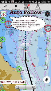
√ Record marine tracks, Autofollow with real-time track overlay
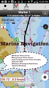
√ Voice Prompts for marine navigation
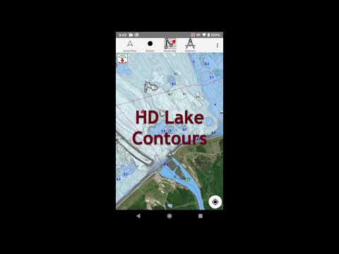
√ HD 1ft/3ft depth lake contour maps for anglers for selected lake maps: for fishing/trolling(freshwater/saltwater).
√ GPX/KML for boat route.
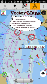
√ Seamless marine chart quilting: Coastal, Approaches,Harbour & Inland ENC(Electronic Marine Charts)
√ Superset of Navionics, C-Map,Lowrance,Argo,Wavve,Savvy Navvy,Predict Wind & Windy.
√ Waypoints
√ Tide & Currents.
√ Marine AIS
√ Anchor Alarm
√ Magnify Text & Icons
√ Wind Prediction Overlay
√ Bearing True/Magnetic
► Fishing Hot Spots AI
►Lake Temperature Maps(Thermoclines 1°F (0.5° C)
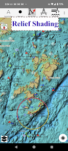
►Relief Shading
► MAPS
Marine chartplotters details!
Unlimited updates for 1 year.
USA:Maps incl NOAA marine charts,ENC,USACE inland river maps & freshwater lake bathymetry maps for 75K+ lakes. Charts incl HD/1ft bathymetry. Incl NOAA marine charts(rasters) w/ NOAA ENC coverage.
Canada:CHS data Incl Great lakes,Alberta & Ontario lakes,Lake Simcoe&Trent Severn Canal,Quebec reservoirs.
UK/Ireland:UKHO marine charts
Germany:BSH charts,Waterways & rivers.
France
Europe Inland Rivers:Donau/Danube/Dunaja,Rhine,Rhein
Australia
Netherland/Holland
Croatia
Finland
Norway
Sweden
Brazil
Spain
Malta,Cypress,Mediterranean Sea
Caribbean
New Zealand
Denmark,Greenland,Faroe
Seychelles,Mauritius,Tanzania
Falklands
Malaysia,South China Sea
Persian/Arabian Gulf,Red Sea
South Africa
Argentina
Iceland
Fiji
Estonia,Latvia,Poland,Lithuania
Turkey,Greece,Italy
►Instrumentation
√Marine AIS & (NMEA AIS and GPS - TCP/UDP)
√Wind direction & Speed,Marine Sonar depth,Water temperature
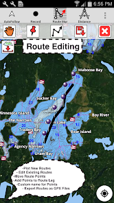
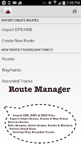
►ROUTE MANAGEMENT/TRIP PLANNING
√Create/Edit/Reverse Boat Routes
√Waypoints mgt
√Import GPX,KML & KMZ files
√Share/Export Routes,Boating log,Tracks&Markers
►BOAT NAVIGATION
√Auto Follow
*Real Time Overlay & Predicted Path Vector
*Course Up
*Speed & Heading
√ Route Assistance With Voice Prompts
*approaching boating route marker prompt
*RT nautical distance & ETA
*sailing/boating off route/wrong direction
√ Record Tracks
►TIDE & CURRENTS
*High/Low Tides
*Tidal Current Prediction
►Marine Weather
*GFS+ ECMWF
►SHARING
*Export GPX.
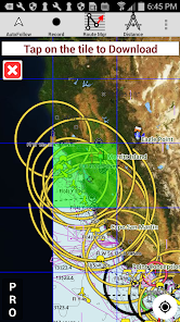
►Satellite Imagery
►USA Marine Charts
*Texas Lakes Texoma,Eufaula,Toledo Bend
*California Lakes Tahoe,Shasta
Pennsylvania Lakes Raystown
Florida Lakes Okeechobee,Kissimmee
*Minnesota Lakes Minnetonka,Waconia,Leech,Mille Lacs
*Massachussets lakes Quabbin
*Missouri Lakes Truman
*Ohio Lake maps Lake hoover
*Wisconsin Lakes Winnebago,Pepin
* Utah Lake Powell,Bear
*Maine Lake Sebago
*Alaska Lakes:Winnipesaukee
*Tennessee Lake Barkley,Norris,Watts Bar
*South Carolina Lake Keowee,Hartwell,Murray
*Lake Michigan,Huron,Ontario,Superior,Erie
►Canada Lakes Maps
*Lac Saint Jean
*Ontario Lake depth maps
*Rideau Canal-Ottawa River
*British Columbia Marine Charts
*Pacific Coast-Vancouver-Haida Gwaii
*Nova Scotia -Bay of Fundy
*Quebec-Anticosti Island
*Newfoundland
*St Lawrence river
*Manitoba & Saskatchewan
*Georgian Bay
*Puget Sound
►UK Nautical Charts
*Scotland
*Thames Estuary
*Ireland
►Australia Marine & Lake Maps
*NSW
*Queensland
Nautical Charts w/course up orientation. Incl Tide Charts & Currents prediction for nautical navigation. Create Boat routes / Waypoints, or import existing GPX/KML routes on device. Has Marine AIS(NMEA) support.
►FEATURES
√ GPU accelerated offline vector NOAA charts/ENC charts (text stays upright)
√ Lake depth map shading/safety lake depth contours:custom boat safety depth
√ Maritime Aids to Boat Navigation : Beacons,Buoys,Boat Launch areas,Boat Ramps,Marina, Fishing Attractors
√ Record marine tracks, Autofollow with real-time track overlay
√ Voice Prompts for marine navigation
√ HD 1ft/3ft depth lake contour maps for anglers for selected lake maps: for fishing/trolling(freshwater/saltwater).
√ GPX/KML for boat route.
√ Seamless marine chart quilting: Coastal, Approaches,Harbour & Inland ENC(Electronic Marine Charts)
√ Superset of Navionics, C-Map,Lowrance,Argo,Wavve,Savvy Navvy,Predict Wind & Windy.
√ Waypoints
√ Tide & Currents.
√ Marine AIS
√ Anchor Alarm
√ Magnify Text & Icons
√ Wind Prediction Overlay
√ Bearing True/Magnetic
► Fishing Hot Spots AI
►Lake Temperature Maps(Thermoclines 1°F (0.5° C)
►Relief Shading
► MAPS
Marine chartplotters details!
Unlimited updates for 1 year.
USA:Maps incl NOAA marine charts,ENC,USACE inland river maps & freshwater lake bathymetry maps for 75K+ lakes. Charts incl HD/1ft bathymetry. Incl NOAA marine charts(rasters) w/ NOAA ENC coverage.
Canada:CHS data Incl Great lakes,Alberta & Ontario lakes,Lake Simcoe&Trent Severn Canal,Quebec reservoirs.
UK/Ireland:UKHO marine charts
Germany:BSH charts,Waterways & rivers.
France
Europe Inland Rivers:Donau/Danube/Dunaja,Rhine,Rhein
Australia
Netherland/Holland
Croatia
Finland
Norway
Sweden
Brazil
Spain
Malta,Cypress,Mediterranean Sea
Caribbean
New Zealand
Denmark,Greenland,Faroe
Seychelles,Mauritius,Tanzania
Falklands
Malaysia,South China Sea
Persian/Arabian Gulf,Red Sea
South Africa
Argentina
Iceland
Fiji
Estonia,Latvia,Poland,Lithuania
Turkey,Greece,Italy
►Instrumentation
√Marine AIS & (NMEA AIS and GPS - TCP/UDP)
√Wind direction & Speed,Marine Sonar depth,Water temperature
►ROUTE MANAGEMENT/TRIP PLANNING
√Create/Edit/Reverse Boat Routes
√Waypoints mgt
√Import GPX,KML & KMZ files
√Share/Export Routes,Boating log,Tracks&Markers
►BOAT NAVIGATION
√Auto Follow
*Real Time Overlay & Predicted Path Vector
*Course Up
*Speed & Heading
√ Route Assistance With Voice Prompts
*approaching boating route marker prompt
*RT nautical distance & ETA
*sailing/boating off route/wrong direction
√ Record Tracks
►TIDE & CURRENTS
*High/Low Tides
*Tidal Current Prediction
►Marine Weather
*GFS+ ECMWF
►SHARING
*Export GPX.
►Satellite Imagery
►USA Marine Charts
*Texas Lakes Texoma,Eufaula,Toledo Bend
*California Lakes Tahoe,Shasta
Pennsylvania Lakes Raystown
Florida Lakes Okeechobee,Kissimmee
*Minnesota Lakes Minnetonka,Waconia,Leech,Mille Lacs
*Massachussets lakes Quabbin
*Missouri Lakes Truman
*Ohio Lake maps Lake hoover
*Wisconsin Lakes Winnebago,Pepin
* Utah Lake Powell,Bear
*Maine Lake Sebago
*Alaska Lakes:Winnipesaukee
*Tennessee Lake Barkley,Norris,Watts Bar
*South Carolina Lake Keowee,Hartwell,Murray
*Lake Michigan,Huron,Ontario,Superior,Erie
►Canada Lakes Maps
*Lac Saint Jean
*Ontario Lake depth maps
*Rideau Canal-Ottawa River
*British Columbia Marine Charts
*Pacific Coast-Vancouver-Haida Gwaii
*Nova Scotia -Bay of Fundy
*Quebec-Anticosti Island
*Newfoundland
*St Lawrence river
*Manitoba & Saskatchewan
*Georgian Bay
*Puget Sound
►UK Nautical Charts
*Scotland
*Thames Estuary
*Ireland
►Australia Marine & Lake Maps
*NSW
*Queensland
Updated on
Safety starts with understanding how developers collect and share your data. Data privacy and security practices may vary based on your use, region, and age. The developer provided this information and may update it over time.

No data shared with third parties
Learn more about how developers declare sharing

This app may collect these data types
Location and Personal info

Data is encrypted in transit

You can request that data be deleted
Ratings and reviews
4.2
11.1K reviews

B H
- Flag inappropriate
- Show review history
September 20, 2025
update: the feature I loved is only free for a few days, super disappointed. I've had the app for 5 minutes and love it already. I love the route tracing option. The only suggestion I have if not already an option is to be able to mark objects in the water. we have a few big branches that have stuck themselves in the mud that would be nice to know where they are when the water is churned up.

kevin cox
- Flag inappropriate
- Show review history
September 5, 2025
I have had fun playing with this app. I have used it on bodies of water I regularly fish, to try it out. The depths and contour lines are not always accurate, and the fishing ai is geared toward warm water species, not the salmon and lake trout I fish for in deep water. At least one of the lakes is mis-named. However, I have had fun plotting courses and routes for trolling. Also, the app is fairly easy to use. I have wasted 20 bucks on a lot of worse things.

Chris Burgin
- Flag inappropriate
- Show review history
August 1, 2025
Updated: after going to a new lake decided to give another try. With sale, $ was too good not to. You can find these maps out there you have to really hunt. This puts them all in 1 place and overlays. Not only your location but routing, hazards, waypoints including personal, and weather. Looks promising and will try over next few weeks. Original:Really good for about the first day then they want you to pay for everything and anything. These maps are free. Don't know why they insist on charging.
13 people found this review helpful
Gps Nautical Charts
April 7, 2023
The price includes access to offline charts, support for NMEA + AIS, offline tide & Currents, automatic routing, voice assistance, custom depth shading , depth offset, magnetic bearing, satellite aerials, custom units, night mode, GPS features and tons of other features.
What’s new
AIS updates
Highlight Fishing Depth Range
RELIEF SHADING
Lake Temperature
Marine Weather Forecast
Fishing AI
NMEA ALARMS:Depth+Wind
Marine Weather:Wind,Wave
Automatic Boat Routing
-UK Tide & Currents
-Magnetic Bearing
-Wind Prediction Overlay
-Magnify Text+Icons
-Anchor alarm
- Auto Pilot
-Custom depth shading
-Satellite imagery
-AIS &GPS NMEA TCP/UDP
-Russian rivers(Volga)
-Wind speed,direction,sonar depth,water temp
Norway,Finland,Denmark
German(Donau,Elbe,Mosel,Rhein,Saar,Weser)
Elbe,Ruhr
App support
About the developer


