

GlobeViewer PRO

10+
Yuklanmalar

3+
info


Bu ilova haqida
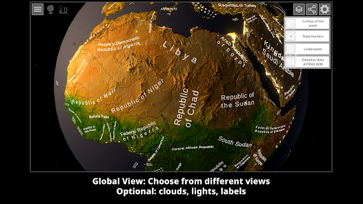
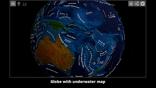
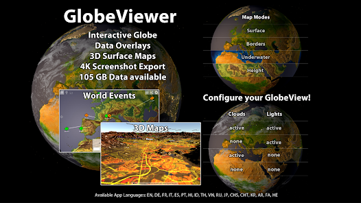
This app enables a high-quality view of the surface of our blue planet. It is divided into two areas: the rotatable, global view as an interactive globe and a high-resolution 3D map representation of the Earth's topography.
- Interactive 3D globe with surface, underwater and topography maps
- High-resolution 3D topography map set of the entire Earth's surface - divided into 22,912 individual tiles.
You can load 110 different regions onto the interactive globe, which then present the many individual tiles in a meaningful, connected way and reload them automatically. The app initially only contains the textures for the globe in low resolution. All required downloads are automatically loaded from our server. A total of around 105 GB of data is available. The data remains in the cache on your device for offline use, but can be deleted at any time in the main menu. Furthermore, all events recorded by the GDACS, such as hurricanes, earthquakes, etc., are entered on the globe.
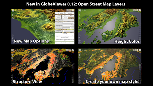
The 3D topography map is based on the elevation data from the NASA Terra probe, which recorded 83° of the northern and southern hemispheres between 2000 and 2013 - this is the result of the ASTER3-DEM. With version 0.10.0, the map is enriched with around 7.5 million place names from geonames.org. This means that all the towns, mountains, lakes, deserts and many other geographical features entered there are shown on the map. From version 0.12.0, data from OpenStreetMaps (buildings, borders, streets...) is also available on the tiles - but only for the demos and the purchased maps.
Use the tutorial in the app to get started quickly or read the manual to find out which functions are included in this app. Since the app is still under development, some functions may still change.
We hope you enjoy using GlobeViewer!
- Interactive 3D globe with surface, underwater and topography maps
- High-resolution 3D topography map set of the entire Earth's surface - divided into 22,912 individual tiles.
You can load 110 different regions onto the interactive globe, which then present the many individual tiles in a meaningful, connected way and reload them automatically. The app initially only contains the textures for the globe in low resolution. All required downloads are automatically loaded from our server. A total of around 105 GB of data is available. The data remains in the cache on your device for offline use, but can be deleted at any time in the main menu. Furthermore, all events recorded by the GDACS, such as hurricanes, earthquakes, etc., are entered on the globe.
The 3D topography map is based on the elevation data from the NASA Terra probe, which recorded 83° of the northern and southern hemispheres between 2000 and 2013 - this is the result of the ASTER3-DEM. With version 0.10.0, the map is enriched with around 7.5 million place names from geonames.org. This means that all the towns, mountains, lakes, deserts and many other geographical features entered there are shown on the map. From version 0.12.0, data from OpenStreetMaps (buildings, borders, streets...) is also available on the tiles - but only for the demos and the purchased maps.
Use the tutorial in the app to get started quickly or read the manual to find out which functions are included in this app. Since the app is still under development, some functions may still change.
We hope you enjoy using GlobeViewer!
Oxirgi yangilanish
Xavfsizlik — dastur ishlab chiquvchilar maʼlumotlaringizni qanday jamlashi va ulashishini tushunishdan boshlanadi. Maʼlumotlar maxfiyligi va xavfsizlik amaliyotlari ilovadan foydalanish, hudud va yoshga qarab farq qilishi mumkin. Bu axborot dastur ishlab chiquvchi tomonidan taqdim etilgan va keyinchalik yangilanishi mumkin.

Tashqi hamkorlarga hech qanday axborot ulashilmagan
Dastur ishlab chiquvchilar axborot ulashilishini qanday aytishi haqida batafsil

Hech qanday maʼlumot jamlanmagan
Dastur ishlab chiquvchilar axborot jamlanishini qanday aytishi haqida batafsil

Maʼlumotlar uzatish vaqtida shifrlanadi

Maʼlumotlar oʻchmaydi
Nima yangiliklar
Technical update to Unity2022.3.61
Ilova yuzasidan yordam
Dasturchi haqida
Ralf Armin Böttcher, Softwareentwicklung
Bergstr. 1
18209 Bad Doberan
Germany
+49 1512 8119724


